Planning & Engineering Design

Geomatiktechniker/in BP

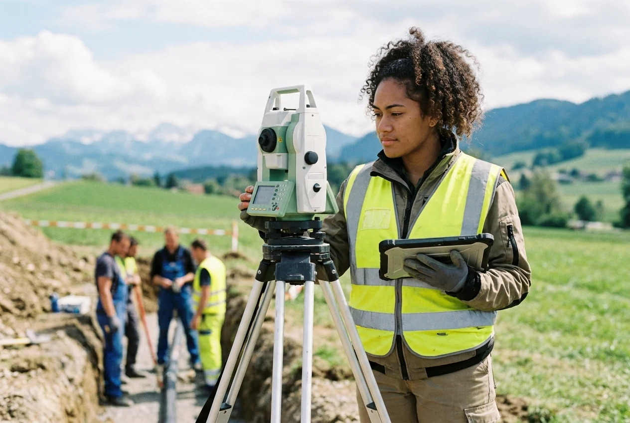
You capture and analyse spatial data for sustainable construction and planning projects.

Geomatiktechniker/in BP

01 · Overview

What this profession is about

As surveying specialists, you collect data in the field, analyse it in the office, and coordinate construction projects.

Measure the world precisely and map it digitally: Geomatiktechniker/in BP are the key figures for modern construction and spatial planning. You combine demanding fieldwork with highly technical data analysis. Whether on rainy construction sites or in a climate-controlled office, your measurements and models ensure that bridges, tunnels, and roads are built safely and sustainably. Your expertise forms the foundation for every major infrastructure project.

FieldPlanning & Engineering Design
Education pathContinuing Education Profession
IndustryPlanning & Civil Engineering
Swissdoc 0.410.19.0

02 · Salary

What you can earn

MedianCHF 90'580
CHF 60'000CHF 118'000
✓ Strong salary match
Salaries reflect Swiss market data. Range covers entry to senior. Salary reference based on Geomatics Engineer. Based on 92 observations, updated 7 months ago.

Salary by experience

80k100k120kmedian 91k81k85k92k101k105k125k0-2 yrs3-5 yrs6-8 yrs9-11 yrs12-21 yrs21+ yrs
View as table
ExperienceSalary (CHF)
0-2 yrsCHF 80'635
3-5 yrsCHF 85'400
6-8 yrsCHF 92'080
9-11 yrsCHF 100'600
12-21 yrsCHF 105'000
21+ yrsCHF 125'000

Salary trend

+30% over decade
80k90k100k82k89k88k106k2014-20162017-20192020-20222023-2025
View as table
PeriodSalary (CHF)
2014-2016CHF 81'500
2017-2019CHF 88'884
2020-2022CHF 88'200
2023-2025CHF 105'625

Top earning cantons

  • VaudCHF 97'50017 obs.
  • ZurichCHF 96'95020 obs.
View as table
CantonSalaryObs.
VaudCHF 97'50017
ZurichCHF 96'95020

Top paying industries

  • UtilitiesCHF 125'0005 obs.
  • Information technology / TelecomCHF 106'0005 obs.
  • Service sector in generalCHF 103'5355 obs.
  • Building trade / Real estateCHF 90'00060 obs.
View as table
IndustrySalaryObs.
UtilitiesCHF 125'0005
Information technology / TelecomCHF 106'0005
Service sector in generalCHF 103'5355
Building trade / Real estateCHF 90'00060

03 · Pathway

How to enter and grow

Swiss training pathway available in the full profile

  • 🎓 Geomatiktechniker/in mit eidg. Fachausweis

Official education path

The two-year part-time training provides the necessary qualifications for the federal professional examination in modules.

Typical training path

Geomatiktechniker/in mit eidg. Fachausweis

Prerequisites

  • Completion of vocational basic training as Geomatiker/in EFZ and 4 years of professional practice with a workload of at least 80%, of which 2 years in the field of geomatics
  • Completion of another technical basic training or equivalent qualification and 4 years of professional practice with a workload of at least 80% in the field of geomatics
  • Required module completions or equivalence certificates

Requirements

  • IT skills
  • Careful working style
  • Organisational talent
  • Ability to lead staff and work in a team

04 · Skills & fit

What it takes

Required skills

  • Precision in the field
  • Technical understanding
  • Leadership skills
  • Organisational skills

Personality fit

  • Swiss career path
  • Career transition
  • Professional growth

05 · Daily reality

What the work feels like

Typical day

In the early morning, you set up satellite-guided measuring instruments on the construction site with your team and check the markings. After collecting the data, you move to the office to verify the coordinates in the geographic information system and draft initial plans.

  • You capture and measure spatial data precisely in the field and on active construction sites.
  • You position and calibrate satellite-guided measuring instruments for exact height and location determination.
  • You analyse and model collected data in the geographic information system.
  • You coordinate project schedules, monitor costs, and manage workflows.
  • You lead teams, instruct staff, and supervise trainees.
  • You create graphical representations and plans for construction projects.
  • You make geographic information publicly available via web technologies.
  • You strictly adhere to occupational safety and environmental protection regulations.

Working conditions

You work in high-rise, civil engineering, and architectural offices, as well as in the public sector. You are often on construction sites, working outdoors on tunnel, road, or bridge construction projects.

Where to learn

Strengths

  • Precision in the field
  • Technical understanding
  • Leadership skills
  • Organisational skills

Trade-offs

  • Weather dependency
  • Physical strain
  • Responsibility pressure
  • Changing work locations

06 · Similar

You might also explore

All in Planning & Engineering Design